A few weeks ago, China launched the final satellite in its BeiDou-3 satellite positioning system. Didn’t know that China had its own GPS? How about Europe’s Galileo, Russia’s GLONASS, or Japan’s QZSS? There’s a whole world of GPS-alikes out there. Let’s take a look.
The Global Positioning System (GPS) that we all know and love flew its first satellite in the distant past of 1978, just five years after the project began. Becoming fully operational in 1993, it was originally intended for use by the military. After decrees by government and the increase in civilian accuracy in 2000, GPS took the world by storm.
While open access to GPS spawned new industries and made navigation easier for everyone, governments worldwide were keenly aware that such a useful system was under the sole control of the United States. As more came to rely on it for day to day activities, it became clear to many that it would be advantageous to have a system under their own control.
These factors have led to the development of a spate of satellite navigation systems being developed by other nation states. Russia’s GLONASS, the European Union’s Galileo, and China’s BeiDou navigation system all offer comparable functionality to GPS. Meanwhile, Japan and India have both undertaken the construction of regional navigational systems, with QZSS and NAVIC, respectively. Each have their own unique qualities, and it bears learning about the relative systems and what they bring to satellite navigation.
GLONASS
The oldest system next to GPS, GLONASS was developed by the Soviet Union, kicking off in 1976. A little slower to come together, its full constellation of satellites was first completed in 1995. Russian economic issues led to the system falling out of maintenance, and global coverage was lost a few short years later.
It was only in the new millenium that proper funding was restored to the project. Since then, GLONASS has become a priority of Russian leadership, taking a full third of the Roscosmos budget. Global coverage was once again reached in 2013.
At its standard level of operation, GLONASS offers between 4.5 m and 7.4 m of accuracy – competitive with unaugmented GPS. Despite this, it was late to the party, and initially failed to find acceptance as GPS was already the favored choice. Regulations were put in place for a 25% import tariff for any GPS navigation device that didn’t also support GLONASS. This political move quickly changed things, with manufacturers making the effort to create devices that could take advantage of both satellite navigation systems. This had the additional benefit of improving acquire time, as receivers had a broader set of satellites from which to receive a fix.
Galileo
Kicking off in 1999, The European Union’s Galileo system was nearly scuppered before it got started, with the United States having severe reservations about the program. With the system offering high accuracy navigation to anyone and everyone, the US feared it could be used in attacks on its home territory. With the original frequency plan, it would be impractical for US forces to jam Galileo transmissions without also interfering with GPS used for their own weapons. However, the EU pushed on, coming to a compromise that the system would be built, albeit in a way that would leave the two systems using suitably seperate frequency allocations. The first craft was launched took place in 2011, with launches taking place thick and fast ever since.
Currently, 22 satellites are operational out of a planned total 30: 24 to be in use, and 6 on active standby. Coverage is considered global, while likely not yet perfect until the constellation is completed sometime this year. Through the use of Precise Point Positioning technology, Galileo offers accuracy to the centimetric level in its high accuracy mode, without requiring any communications with base-stations like augmented GPS or RTK.
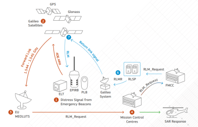
Plans also include implementing rudimentary two-way communication for the Galileo Search-and-Rescue service, allowing first responders to indicate to those seeking assistance that their call has been received and help is on the way.
BeiDou
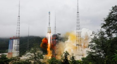
Spawned from discussions in the 1980s, China’s Beidou system kicked off with BeiDou-1, with the first launch taking place in 2000. A China-only regional system, it was superseded by BeiDou-2 which began launches in 2007 which began the march towards more global coverage. 2015 marked the start of BeiDou-3 deployment, with the final satellite of the constellation being launched on June 22, 2020.
With accuracy on the order of 10 meters for civilian use, it also delivers a military-only signal to the armies of China and Pakistan, reportedly down to 10 cm. Short messaging capability is also included in the platform, though whether this will be available to the general public is not clear at this time. Around 70% of Chinese smartphones already support the system. With China’s huge manufacturing muscle and massive population, expect BeiDou hardware to become commonplace incredibly quickly.
Regional Systems
Creating a global satellite navigation system is incredibly expensive. While the economic benefits can be huge, they’re not always readily capturable by those implementing the system, particularly now in a world where we have four. However, that doesn’t mean there aren’t gains to be had from throwing up a few satellites to augment things locally.
Japan’s QZSS system does just that, acting as a local support to standard GPS satellites. The goal was to create a regionally-specific system to help with GPS reception in urban canyons, where tall buildings make it difficult for receivers on the ground to see enough satellites to get a fix. Signals transmitted from the satellites are compatible with standard GPS receivers. First launched in 2010, the constellation currently consists of four satellites, with a further three planned.

India’s NAVIC system was partially borne out of a loss of GPS access in the midst of the Kargil War in 1999. The first launch took place in 2013, with the system declared operational five years later. With seven satellites currently in use, coverage extends up to 1,600 km from India’s borders. Using a dual-band system with transmissions at 1176 MHz and 2492 MHz to calculate atmospheric distortion, it aims to offer better accuracy than unaugmented GPS.
As in Russia, India is using goverment legislation to push adoption, and deals signed suggest smartphones could work with NAVIC signals as soon as this year.
What It Means For Users
For the average user on the street, the new systems coming online won’t be particularly noticable. It’s likely that smartphone chipsets will pack functionality with most, if not all, systems moving forward, allowing quicker fixes and more accurate positioning. For makers and hackers, there will be more options than ever for satellite navigation modules. For those seeking access to the most satellites possible, units like the ublox NEO-M8U will be attractive. Combined GPS/GLONASS receivers have already been around for years. Anyone out there using Galileo’s centimeter-level resolution?
For nation states, their leaders may sleep a little more soundly knowing that their military has accurate strike capabilities on lock, regardless of the whims of the USA. Conversely, they may fear their adversaries hitting their own soft targets with more precision than ever before. Realistically, positioning systems will just be yet another front on which electronic warfare rages on the battlefield. Incidents like Iran’s use of GPS spoofing are a great example of how these systems can be used and abused.
Regardless, it’s an exciting time for those interested in the cutting-edge of positioning technologies. We look forward to ever-more accurate data helping out with new technologies like drone deliveries, self driving cars, and just finding your way to that new happening coffee shop across town!
No comments:
Post a Comment